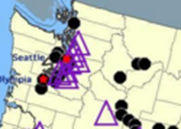
 "HammerheadFistpunch" (hammerheadfistpunch)
04/11/2016 at 18:30 Ľ Filed to: None
 2
2
 72
72|
"HammerheadFistpunch" (hammerheadfistpunch)
04/11/2016 at 18:30 Ľ Filed to: None | 2
| 72 |
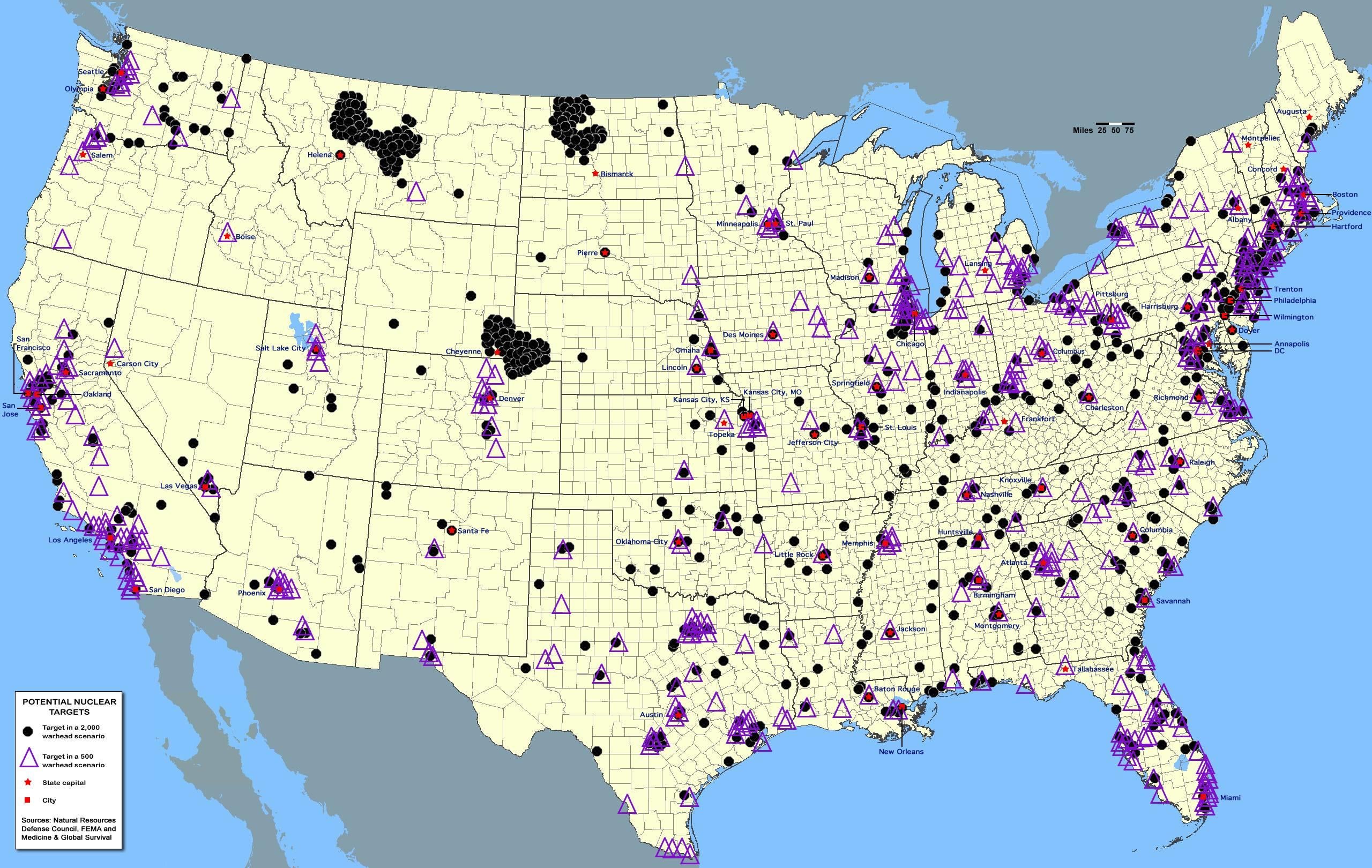
FEMA possible nuclear target list Circa 1980
Iĺm pretty well and truly instant toast where I am now, but I could get to safety pretty easy.
 Steve in Manhattan
> HammerheadFistpunch
Steve in Manhattan
> HammerheadFistpunch
04/11/2016 at 18:33 |
|
Iĺm pretty much toast ....
 jkm7680
> HammerheadFistpunch
jkm7680
> HammerheadFistpunch
04/11/2016 at 18:34 |
|
Iĺm very burnt toast.
|
HammerheadFistpunch
> Steve in Manhattan
04/11/2016 at 18:34 |
|
yeeeeah...sorry.
 RamblinRover Luxury-Yacht
> HammerheadFistpunch
RamblinRover Luxury-Yacht
> HammerheadFistpunch
04/11/2016 at 18:35 |
|
Uh, negative. I am a meat popsicle.
!!! UNKNOWN CONTENT TYPE !!!
 Daily Drives a Dragon - One Last Lap
> HammerheadFistpunch
Daily Drives a Dragon - One Last Lap
> HammerheadFistpunch
04/11/2016 at 18:37 |
|
I'm getting decently toasty
 vicali
> HammerheadFistpunch
vicali
> HammerheadFistpunch
04/11/2016 at 18:39 |
|
Sitting in Canada with the popcorn..
|
HammerheadFistpunch
> RamblinRover Luxury-Yacht
04/11/2016 at 18:39 |
|
smoke you man!
|
HammerheadFistpunch
> vicali
04/11/2016 at 18:39 |
|
howĺs your popcorn doing?
 sm70- why not Duesenberg?
> HammerheadFistpunch
sm70- why not Duesenberg?
> HammerheadFistpunch
04/11/2016 at 18:40 |
|
Black circles and a triangle. Very toast.
 Hot Takes Salesman
> HammerheadFistpunch
Hot Takes Salesman
> HammerheadFistpunch
04/11/2016 at 18:40 |
|
Long Island, New York is fucking sunk in this scenario.
 TheBloody, Oppositelock lives on in our shitposts.
> HammerheadFistpunch
TheBloody, Oppositelock lives on in our shitposts.
> HammerheadFistpunch
04/11/2016 at 18:41 |
|
Yep, Iĺm boned...
 dtg11 - is probably on an adventure with Clifford
> HammerheadFistpunch
dtg11 - is probably on an adventure with Clifford
> HammerheadFistpunch
04/11/2016 at 18:42 |
|
Iĺm instatoast
 Spaceball-Two
> HammerheadFistpunch
Spaceball-Two
> HammerheadFistpunch
04/11/2016 at 18:42 |
|
TOASTY!
 Arch Duke Maxyenko, Shit Talk Extraordinaire
> HammerheadFistpunch
Arch Duke Maxyenko, Shit Talk Extraordinaire
> HammerheadFistpunch
04/11/2016 at 18:43 |
|
First strike target because of GE Aviation.
 Frank Grimes
> HammerheadFistpunch
Frank Grimes
> HammerheadFistpunch
04/11/2016 at 18:43 |
|
why would they nuke utah there is nothing here except fry sauce.
 You can tell a Finn but you can't tell him much
> HammerheadFistpunch
You can tell a Finn but you can't tell him much
> HammerheadFistpunch
04/11/2016 at 18:43 |
|
Iĺm latent toast that just happens to be directly downwind from instant toast regardless of the scenario. Letĺs see, toast is a 4 hour drive due west. Depending on winds and how high the blast cloud goes it would probably be about 4-8 hours before the radioactive snowflakes start falling on me.
 Highlander-Datsuns are Forever
> HammerheadFistpunch
Highlander-Datsuns are Forever
> HammerheadFistpunch
04/11/2016 at 18:44 |
|
All those black dots in ND, MT, CO, WY, and NB are in ground ICBM sites. So it just depends on which way the wind is blowing.
|
Spaceball-Two
> Frank Grimes
04/11/2016 at 18:44 |
|
Hill Air Force Base.
 Little Black Coupe Turned Silver
> HammerheadFistpunch
Little Black Coupe Turned Silver
> HammerheadFistpunch
04/11/2016 at 18:44 |
|
Hometown = Nothing
Current city = Black dot, for unknown reasons...
|
vicali
> HammerheadFistpunch
04/11/2016 at 18:45 |
|
a little chewy..
Why are they going to blow up the top of Idaho? There is nothing there.
 Nymphicus Hollandicus
> HammerheadFistpunch
Nymphicus Hollandicus
> HammerheadFistpunch
04/11/2016 at 18:46 |
|
Iĺm absolutely fucked, thereĺs absolutely no where for me to go since I live on Long Island
 For Sweden
> vicali
For Sweden
> vicali
04/11/2016 at 18:46 |
|
It is known that the Soviets would have spared Canada
|
HammerheadFistpunch
> vicali
04/11/2016 at 18:46 |
|
Thatĺs just for a laugh.
 Jake - Has Bad Luck So You Don't Have To
> HammerheadFistpunch
Jake - Has Bad Luck So You Don't Have To
> HammerheadFistpunch
04/11/2016 at 18:47 |
|
Instant toast in both scenarios. Luckily I can drive literally any direction and get away from it.
|
vicali
> For Sweden
04/11/2016 at 18:48 |
|
Maybe no one lived in Canada yet in 1980..
|
HammerheadFistpunch
> Nymphicus Hollandicus
04/11/2016 at 18:48 |
|
well, look on the bright side...the VERY bright side.
|
vicali
> HammerheadFistpunch
04/11/2016 at 18:48 |
|
lol, we have a few extras - letĺs have some fun..
 MLGCarGuy
> HammerheadFistpunch
MLGCarGuy
> HammerheadFistpunch
04/11/2016 at 18:49 |
|
I am instant toast and I will still be instant toast when I escape. Luckily I have Mexico as an option.
|
HammerheadFistpunch
> vicali
04/11/2016 at 18:50 |
|
ôwouldnĺt it be funny, you know, to just nuke the bears?ö
ôOh man, yes!ö
 DrJohannVegas
> HammerheadFistpunch
DrJohannVegas
> HammerheadFistpunch
04/11/2016 at 18:51 |
|
I grew up in a town which was on the ôinstant toastö (500 warhead radius) list back in the day, because of military/industrial significance, but now both of those companies are dust in the wind. So, I am gonna bet that an updated version of this map would look a bit different. Itĺs funny that, with all the discussion of other weapons, the specter of nuclear warfare seems further away.
|
DrJohannVegas
> vicali
04/11/2016 at 18:53 |
|
Canadians: First they want socialized medicine, then they want socialized threat mapping. JEEZ. GET YUR OWN FEMA, EH!?!?
 CTSenVy
> HammerheadFistpunch
CTSenVy
> HammerheadFistpunch
04/11/2016 at 18:54 |
|

|
vicali
> HammerheadFistpunch
04/11/2016 at 18:55 |
|
Ursus americanus?
Getĺem
 lone_liberal
> HammerheadFistpunch
lone_liberal
> HammerheadFistpunch
04/11/2016 at 18:56 |
|
At that time I would have been toast since the local AFB had a B52 squadron assigned to it complete with nukes. Now the same base has KC-130 tankers assigned instead so that probably has changed.
 Shamoononon drives like a farmer
> HammerheadFistpunch
Shamoononon drives like a farmer
> HammerheadFistpunch
04/11/2016 at 18:56 |
|
Yeah, San Diego. So many military bases that Iĺm surprised weĺre not marked for worse.
|
vicali
> DrJohannVegas
04/11/2016 at 18:56 |
|
Iĺve contacted the appropriate ministry, and this is what they sent;
|
HammerheadFistpunch
> Shamoononon drives like a farmer
04/11/2016 at 18:57 |
|
thereĺs a worse?!
|
Shamoononon drives like a farmer
> HammerheadFistpunch
04/11/2016 at 19:02 |
|
Looked like LA and San Francisco had more.
|
Frank Grimes
> Spaceball-Two
04/11/2016 at 19:03 |
|
Wait they know about that?!
yeah but thats far away from me.
 Sam
> HammerheadFistpunch
Sam
> HammerheadFistpunch
04/11/2016 at 19:04 |
|
4 triangles and 2 black circles. Shit.
|
Spaceball-Two
> Frank Grimes
04/11/2016 at 19:07 |
|
Maybe they just really hate Scone Cutter and Crown Burger. Commie bastards.
|
CTSenVy
> vicali
04/11/2016 at 19:08 |
|
Military radar/sonar base.
 interstate366, now In The Industry
> HammerheadFistpunch
interstate366, now In The Industry
> HammerheadFistpunch
04/11/2016 at 19:11 |
|
Iĺd have been screwed. South of Richmond, right next to Fort Lee (the triangle just southeast of the city) and northeast of Fort Pickett, which is the black dot nearby. At least I could head a bit northwest and be sort of safe, unlike those poor souls in Hampton Roads.
 Wrong Wheel Drive (41%)
> HammerheadFistpunch
Wrong Wheel Drive (41%)
> HammerheadFistpunch
04/11/2016 at 19:13 |
|
I am liquefied toast in the northeast lol
 If only EssExTee could be so grossly incandescent
> HammerheadFistpunch
If only EssExTee could be so grossly incandescent
> HammerheadFistpunch
04/11/2016 at 19:17 |
|
Marthaĺs Vineyard. Weĺll survive for a while depending on time of year. If itĺs winter, weĺre limited by food stores and oil reserves. In the summer weĺll last longer (local agriculture ftw) but the power station here canĺt run the entire island for long and has to be supplemented by underwater power lines. If power stops coming through those things will slowly start to slide downhill. Generally though, as long as we escape fallout our isolation from the outside world will be an asset.
|
Wrong Wheel Drive (41%)
> Highlander-Datsuns are Forever
04/11/2016 at 19:17 |
|
It's okay, all of those warheads would have launched to destroy the rest of the world ten times over
|
CTSenVy
> sm70- why not Duesenberg?
04/11/2016 at 19:22 |
|
Thanks to SAC in Bellevue, Omaha was always 3rd on the Soviet to nuke list.
 Stapleface
> HammerheadFistpunch
Stapleface
> HammerheadFistpunch
04/11/2016 at 19:38 |
|
Iĺm in Jersey. Iĺm probably pretty much instantly glow in the dark
 shop-teacher
> HammerheadFistpunch
shop-teacher
> HammerheadFistpunch
04/11/2016 at 19:47 |
|
Instant toast! No hope of escape.
After September 11th, when I was still in Architecture school, I learned a couple of interesting things. The first thing I learned was that one of my friends/classmates was the daughter of the commander of the Pacific fleet. The second thing I learned (from her) was that the #7 ranked terrorist target in the nation, according to the DoD at the time, was in a building I could see out my apartmentĺs kitchen window.
 DeLM
> HammerheadFistpunch
DeLM
> HammerheadFistpunch
04/11/2016 at 19:51 |
|
i really donĺt get the concentration on n dakota or wyoming? whatĺs up there?
 spanfucker retire bitch
> HammerheadFistpunch
spanfucker retire bitch
> HammerheadFistpunch
04/11/2016 at 19:52 |
|
Niagara Falls Dam and Air Force base have been on the target list for I donĺt even know how many decades.
All my old brick schools (the high school is newer and doesnĺt have them) still have Fallout shelter signs in and around the entrances. I wouldnĺt be affected directly by the blast in Lockport, but my life would be very miserable very quickly.
 norskracer98-ExploringTheOutback
> HammerheadFistpunch
norskracer98-ExploringTheOutback
> HammerheadFistpunch
04/11/2016 at 20:24 |
|
Iĺmwithin 10 miles of 3 nuclear plants so Iĺm SOL
 sonicgabe
> HammerheadFistpunch
sonicgabe
> HammerheadFistpunch
04/11/2016 at 20:27 |
|
Growing up in Tampa in the 1980s with MacDill AFB just miles away, we knew weĺd go before Washington D.C. Once you figured out what CENTCOM was and that it was housed in our city, the Commie nuclear threat wasnĺt so frightening. Weĺd be wiped off the map before anyone realized what happened. Life is good when thereĺs no need to worry about surviving in a post-apocalyptic nuclear winter.
 leicester
> HammerheadFistpunch
leicester
> HammerheadFistpunch
04/11/2016 at 20:32 |
|
See that black splotch in the middle of the country? Grew up in the middle of those ICBM fields. Now toastily among the triangles in the upper left...
 f-ducket
> HammerheadFistpunch
f-ducket
> HammerheadFistpunch
04/11/2016 at 20:35 |
|
Strange map for the 80s.
Blytheville AFB in Mississippi County, AR not listed. Nor is Loring AFB in Arrowstock County, ME. Both active SAC bases with nuke toting B-52s during the 80s. Actually, Loring was one of SACĺs largest bases and closer to the USSR than any other on the continental US.
 gmporschenut also a fan of hondas
> HammerheadFistpunch
gmporschenut also a fan of hondas
> HammerheadFistpunch
04/11/2016 at 20:58 |
|

truly fucked
what is quite funny was back in the 50's every town within a designated target area, had a duplicate town that residents were supposed to evacuate to. It was funny because
A) the odds of evacuating in time was slim
B) how would a small town of 10k people absorb a town of over 50k
 AMGtech - now with more recalls!
> Frank Grimes
AMGtech - now with more recalls!
> Frank Grimes
04/11/2016 at 20:59 |
|
Maybe they really hate Mormons?
|
gmporschenut also a fan of hondas
> Stapleface
04/11/2016 at 21:06 |
|
and before the nukes start flying!
 KusabiSensei - Captain of the Toronto Maple Leafs
> HammerheadFistpunch
KusabiSensei - Captain of the Toronto Maple Leafs
> HammerheadFistpunch
04/11/2016 at 21:09 |
|
Iĺm dependent upon the weapon yield. If the epicenter is KMGE (Dobbins ARB), I would survive the immediate impact of all but the multi megaton class bombs. Kiloton weapons, Iĺd be out of blast and pressure gradient radius, but still it wouldnĺt be what one calls pleasant.
|
HammerheadFistpunch
> DeLM
04/11/2016 at 21:10 |
|
Missiles
|
DeLM
> HammerheadFistpunch
04/11/2016 at 21:46 |
|
ah, yeah didnĺt even think of that. makes sense. but i donĺt get why there wouldnĺt be more around omaha then with itĺs expansive minute man II network.
|
DeLM
> HammerheadFistpunch
04/11/2016 at 23:01 |
|
well that ended up taking me down the worm hole, 1st looking up/ for missile silos in google earth, then all the craters at the nevada test range then odd out of the way military bases. ahahah thanks; this has been a different sort of night.
 user314
> HammerheadFistpunch
user314
> HammerheadFistpunch
04/11/2016 at 23:05 |
|
Burnt, pulverized toast.
|
HammerheadFistpunch
> DeLM
04/11/2016 at 23:08 |
|
Some of those wormholes trip are rad.
|
HammerheadFistpunch
> user314
04/11/2016 at 23:09 |
|
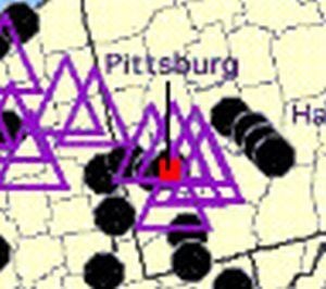
russian icmbĺs ôwe put the pit in pittsburg!ö
 Gone
> HammerheadFistpunch
Gone
> HammerheadFistpunch
04/11/2016 at 23:59 |
|
Every town/city Iĺve ever lived in has at least one triangle. And a bunch where I am now. No escape...
 Dusty Ventures
> HammerheadFistpunch
Dusty Ventures
> HammerheadFistpunch
04/12/2016 at 00:26 |
|
Not only am I inside a purple triangle, but my house is seven miles (an my job 700 feet) away from the reason thereĺs a purple triangle. Iĺm instatoast.
 Jake Huitt - Two Alfas And A Nissan, Not A Single Running Car
> HammerheadFistpunch
Jake Huitt - Two Alfas And A Nissan, Not A Single Running Car
> HammerheadFistpunch
04/12/2016 at 04:29 |
|
Denver, CO. If I get lucky and they only go for Cheyenne mountain, the USAF Academy, and Ft. Carson, Iĺm good. If they decide to take out DIA and Buckley AFB, Iĺm toast.
|
DeLM
> HammerheadFistpunch
04/12/2016 at 08:13 |
|
yes sir, they definitely are.
 MontegoMan562 is a Capri RS Owner
> HammerheadFistpunch
MontegoMan562 is a Capri RS Owner
> HammerheadFistpunch
04/12/2016 at 15:01 |
|
Iĺm in target of about 3 black dots and I think around 10 triangles
Iĺm triple toasted
 Dru
> HammerheadFistpunch
Dru
> HammerheadFistpunch
04/12/2016 at 16:11 |
|
Probably latent toast. That black dot over Myrtle is probably the AFB that slick willy shut down circa Ĺ94. It is now a gentrified planned community full of new jersey retirees, thus equally deserving of annihilation. But the nuclear power plant 70 miles northeast is a solid target.
|
Frank Grimes
> AMGtech - now with more recalls!
04/12/2016 at 21:40 |
|
maybe the chinese are jealous of our large families?